Ocean Drilling Data
|
Core Data from the Deep Sea Drilling Project
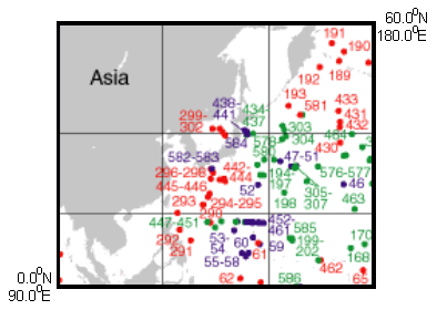
Leg 59 Initial Port: Naha, Okinawa Final Port: Apra, Guam Cruise Dates: February - March, 1978 hole latitude longitude 447 18.0147 133.2895 447A 18.0147 133.2895 448 16.3410 134.8742 448A 16.3410 134.8742 449 18.0307 136.5365 450 18.0003 140.7890 451 18.0147 143.2762 |
Leg 60 Initial Port: Apra, Guam Final Port: Apra, Guam Cruise Dates: March - May, 1978 hole latitude longitude 452 17.6698 148.6288 452A 17.6695 148.6292 453 17.9070 143.6825 454 18.0130 144.5320 454A 18.0130 144.5320 455 17.8543 145.3580 456 17.9113 145.1795 456A 17.9118 145.1813 457 17.8332 145.8170 458 17.8642 146.9343 459 17.8625 147.3015 459A 17.8625 147.3015 459B 17.8625 147.3015 460 17.6690 147.5987 460A 17.6670 147.5860 461 17.7675 147.6863 461A 17.7670 147.6877 |
http://zenith.ngdc.noaa.gov/mgg/geology/drill.html
Main Page |
╬ёэютэ𠸥ЁрэшІр
URL:
http://zeus.wdcb.ru/wdcb/sep/traverses/Philippine_Geotraverse/dataod.html Last revision June 15, 2002