Сейсмотектонический обзор о районе
землетрясения 3 ноября 2002 г. (22:12 UTC)
По данным NEIC, USGS
Seismic Hazard Map
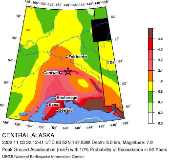 This afternoon a magnitude M 7.9 earthquake ruptured a segment of the
Denali fault in interior Alaska, east of the Parks Highway and the community
of Cantwell. This is the same area as a previous M 6.7 that struck 11 days ago,
on October 23. The Denali fault is a major, seismically active strike-slip fault
that arcs through Alaska, slicing the rugged Alaska Range and bounding the
preciptious north face of Mt. McKinley, the highest peak in North America.
The streams and glacial morraines crossing the fault have been offset and
record the long-term displacement of the fault. Scientists have recognized
that the fault is capable of generating earthquakes as large as magnitude class 8,
but none that large have been recorded in historic time, since the beginning of
the last century. This earthquake likely resulted from slip on the Denali fault
or a closely related fault. No prior historical earthquake having the size of
this earthquake had been definitely attributed to the section of the Denali fault
that lies near the epicenter. However, the section of the fault near the epicenter
had been thought capable of producing a major earthquake on the basis of geologic
evidence and from the nearby occurrence of smaller earthquakes.
This afternoon a magnitude M 7.9 earthquake ruptured a segment of the
Denali fault in interior Alaska, east of the Parks Highway and the community
of Cantwell. This is the same area as a previous M 6.7 that struck 11 days ago,
on October 23. The Denali fault is a major, seismically active strike-slip fault
that arcs through Alaska, slicing the rugged Alaska Range and bounding the
preciptious north face of Mt. McKinley, the highest peak in North America.
The streams and glacial morraines crossing the fault have been offset and
record the long-term displacement of the fault. Scientists have recognized
that the fault is capable of generating earthquakes as large as magnitude class 8,
but none that large have been recorded in historic time, since the beginning of
the last century. This earthquake likely resulted from slip on the Denali fault
or a closely related fault. No prior historical earthquake having the size of
this earthquake had been definitely attributed to the section of the Denali fault
that lies near the epicenter. However, the section of the fault near the epicenter
had been thought capable of producing a major earthquake on the basis of geologic
evidence and from the nearby occurrence of smaller earthquakes.
Global Seismic Hazard Assessment Program -GSHAP
URL:
http://zeus.wdcb.ru/wdcb/sep/strong/20021103/stect.html
Last revision November 4, 2002