Сейсмотектонический обзор о районе
землетрясения 23 октября 2002 г. (11:27 UTC)
По данным NEIC, USGS
This magnitude M 6.7 earthquake ruptured a segment of the Denali fault in
interior Alaska, east of the Parks Highway and the community of Cantwell.
The Denali fault is a major, seismically active strike-slip fault that arcs through
Alaska, slicing the rugged Alaska Range and bounding the preciptious north face of Mt.
McKinley, the highest peak in North America. The streams and glacial morraines crossing
the fault have been offset and record the long-term displacement of the fault.
Scientists believe the fault is capable of generating earthquakes as large as
magnitude class 8, but none that large have been recorded in historic time,
since the beginning of the last century.
This earthquake likely resulted from slip on the Denali fault or a closely
related fault. No prior historical earthquake having the size of this earthquake
had been definitely attributed to the section of the Denali fault that lies near
the epicenter. However, the section of the fault near the epicenter had been thought
capable of producing a major earthquake on the basis of geologic evidence and from
the nearby occurrence of smaller earthquakes.
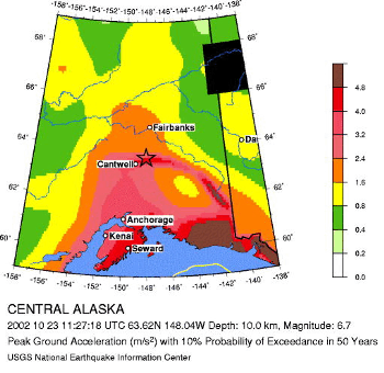
Seismic Hazard Map
 This M 6.7 shock is the largest earthquake on the Denali fault since at least
1912, when a M 7.2 earthquake occurred in the general vicinity of the fault, more
than 50 miles to the east of today's temblor. Since there were no seismographs
operating in Alaska at that time and no reports of surface faulting in the remote
Alaska Range, the location of the 1912 shock is not well-constrained. The second
largest known earthquake on the Denali fault prior to today is a M 6.2 shock that
occurred on August 31, 1958. That shock was centered well east of the Richardson
Highway and the Trans-Alaska Pipeline, more than 100 miles to the east of the fault
segment that broke today.
The seismic behavior of the Denali fault, like the northern and southern segments
of the San Andreas fault in California, is characterized by infrequent large earthquakes.
This behavior contrasts to the segment of the San Andreas in central California
where frequent small earthquakes and continuous fault slip gradually releases
the strain in the Earth's crust caused by global plate tectonic motion.
On a broad-scale, the shallow earthquakes of Central Alaska are occurring within
the North American tectonic plate, as a result of stresses generated by the plate's
interaction with the Pacific tectonic plate. The Pacific plate is moving north-northwest
with respect to the North American plate with a velocity of about 5.2 cm/year
(about 2 inches per year). Much of this relative motion is accommodated at the
principal boundary between the two plates, in the Gulf of Alaska, but there is
also substantial crustal deformation and earthquake activity inland of the plate
boundary, in Central Alaska. In addition to occurring on major mapped faults such
as the Denali fault, shallow-focus earthquakes in Central Alaska also occur on lesser
unmapped faults.
Global Seismic Hazard Assessment Program -GSHAP
This M 6.7 shock is the largest earthquake on the Denali fault since at least
1912, when a M 7.2 earthquake occurred in the general vicinity of the fault, more
than 50 miles to the east of today's temblor. Since there were no seismographs
operating in Alaska at that time and no reports of surface faulting in the remote
Alaska Range, the location of the 1912 shock is not well-constrained. The second
largest known earthquake on the Denali fault prior to today is a M 6.2 shock that
occurred on August 31, 1958. That shock was centered well east of the Richardson
Highway and the Trans-Alaska Pipeline, more than 100 miles to the east of the fault
segment that broke today.
The seismic behavior of the Denali fault, like the northern and southern segments
of the San Andreas fault in California, is characterized by infrequent large earthquakes.
This behavior contrasts to the segment of the San Andreas in central California
where frequent small earthquakes and continuous fault slip gradually releases
the strain in the Earth's crust caused by global plate tectonic motion.
On a broad-scale, the shallow earthquakes of Central Alaska are occurring within
the North American tectonic plate, as a result of stresses generated by the plate's
interaction with the Pacific tectonic plate. The Pacific plate is moving north-northwest
with respect to the North American plate with a velocity of about 5.2 cm/year
(about 2 inches per year). Much of this relative motion is accommodated at the
principal boundary between the two plates, in the Gulf of Alaska, but there is
also substantial crustal deformation and earthquake activity inland of the plate
boundary, in Central Alaska. In addition to occurring on major mapped faults such
as the Denali fault, shallow-focus earthquakes in Central Alaska also occur on lesser
unmapped faults.
Global Seismic Hazard Assessment Program -GSHAP
URL:
http://zeus.wdcb.ru/wdcb/sep/strong/20021023/stect.html
Last revision November 4, 2002