Сейсмотектонический обзор о районе
землетрясения 10 октября 2002 г. (10:50 UTC)
По данным NEIC, USGS
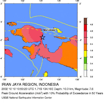
Seismic Hazard Map
The earthquake occurred in a five-hundred kilometer wide diffuse plate
boundary that accommodates the westerly motion of the Philippine Sea and Caroline
plates with respect to the Australian plate. The preliminary epicenter is situated
near the northwest-striking Ransiki fault, one of several major faults that have
been identified in northwestern New Guinea. The focal mechanism is consistent
with the earthquake occurring as right-lateral slip on a northwest-striking fault.
Damaging Historical Earthquakes
In the past few decades, several earthquakes in the area of this recent
earthquake have caused human casualties. On September 12th, 1979 a magnitude
7.9 earthquake stuck about 190 km to the east killing 15 people. Damage estimates
for this quake ranged from $5 to $25 million. Another quake with a magnitude of 6.3
occurred 330 km to the southeast on September 9th, 1985, and killed at least 10 people.
A magnitude 6.3 quake, that injured 28 people, occurred 190 km to the east on
November 20th 1994. And most recently, on September 8th of this year a
magnitude 7.6 struck about 1000 km to the east. This quake killed at least
6 people and generated a one meter tsunami that caused extensive damage to
homes on the nearby islands.
Aftershocks
Generally, large crustal earthquakes generate significant aftershocks.
This event is no exception. Several large aftershocks have already occurred.
Usually, the number of aftershocks decays rapidly over the first few days following
the mainshock but aftershocks can occur several years later.