Положение эпицентра землетрясения
5 марта 2002 г. (21:16 UTC)
По данным NEIC, USGS
65 miles (105 km) W of General Santos, Mindanao, Philippines
[65 миль (105 км) к западу от Дженерал Сантос, Минданао, Филиппины].
The following is a release by the United States Geological Survey,
National Earthquake Information Center:
A major earthquake occurred about 75 miles (120 km) west of General Santos, Mindanao, Philippines or about
620 miles (1005 km) south-southeast of Manila, Philippines at 2:16 PM MST, Mar 5, 2002 (Mar 06 at 5:16 AM local
time in Philippine Islands). The magnitude and location may be revised when additional data and further analysis
results are available.
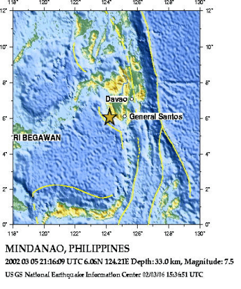
Положение эпицентра землетрясения и глубинное сечение,
составленные Национальным Центром информации о землетрясениях
Геологической службы США (NEIC,USGS), заимствованы с
WEB сайта этой службы.
URL:
http://zeus.wdcb.ru/wdcb/sep/strong/20020305/map.html
Last revision April 10, 2002