Положение эпицентра землетрясения
23 июня 2001 г. (20:33 UTC)
По данным NEIC, USGS
110 miles (175 km) SSE of Puquio, Peru.
[110 миль (175 км) к юго-юго-востоку от Пукуйо, Перу].
A major earthquake occurred NEAR THE COAST OF SOUTHERN PERU,
about 120 miles (190 km) west of Arequipa or about 375 miles (600 km)
southeast of Lima at 4:33 PM EDT on Jun 23, 2001 (3:33 PM local time in
Peru). A REVISED magnitude of 8.4 was computed for this earthquake.
The earthquake occurred along the west coast of Peru, at the boundary
between the Nasca & South American plates. The earthquake resulted from
thrust faulting along this boundary as the Nasca plate subducts beneath
the South American plate. Several moderate aftershocks have also been
recorded, the largest being a magnitude 6.8. Other related effects from
Saturday's earthquake include several landslides as well as a small
coastal tsunami.
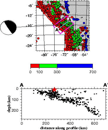
Положение эпицентра землетрясения и глубинное сечение,
составленные Национальным Центром информации о землетрясениях
Геологической службы США (NEIC,USGS), заимствованы с
WEB сайта этой службы.
URL:
http://zeus.wdcb.ru/wdcb/sep/strong/20010623/map.html
Last revision July 09, 2001