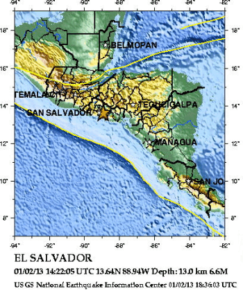
Положение эпицентра землетрясения
13 февраля 2001 г. (14:22 UTC)
По данным NEIC, USGS
15 miles (30 km) east of San Salvador.
[15 миль (30 км) к востоку от г. Сан Сальвадор].
A strong
earthquake occurred IN EL SALVADOR, about 15 miles (30 km) east of San
Salvador at 7:22 AM MST, Feb 13, 2001 (8:22 AM local time in El
Salvador). A REVISED MAGNITUDE OF 6.6 WAS COMPUTED FOR THIS EARTHQUAKE.
The magnitude was revised based on additional processing of available data.
Today's magnitude 6.6 earthquake occurred within the Cocos-Caribbean
subduction zone. El Salvador sits atop the western part of the
Carribbean plate, where it is overriding (subducting) the Cocos plate.
Subduction zones such as this are geologically very complex and produce
numerous earthquakes from multiple sources. Shallow intraplate
(crustal) earthquakes occur within the crust of the overriding Caribbean
plate. Deeper intraplate earthquakes occur within the subducting Cocos
plate. The earthquake sequence underway in the El Salvador region has
involved intraplate faulting in both the Cocos and Caribbean plates,
with the largest earthquake in the sequence (January 13) occurring in
the lower (Cocos) plate.
Today's earthquake was a strong, shallow intraplate earthquake,
occurring within the crust of the overlying Caribbean plate. This
earthquake was a strike-slip faulting earthquake, which likely occurred
in response to the complicated stresses in the Caribbean plate as it
overrides the Cocos plate. It is about 85 km away from the 13 January
magnitude 7.7 earthquake and about 30 km shallower. These two
earthquakes occurred in two different plates.
The occurrence of any large earthquake changes the stresses throughout
the surrounding region. Aftershocks occur in response to these changes.
Occasionally, other earthquakes will occur in response to the altered
regional stresses. While not technically aftershocks, these earthquakes
are related, becoming part of a regional earthquake sequence. Another
example of a regional earthquake sequence is the 1992 Landers-Big Bear
sequence in southern California. The magnitude 7.3 Landers earthquake
was followed by the magnitude 6.4 Big Bear earthquake, which occurred on
a different fault approximately 36 km away.
Положение эпицентра землетрясения показано на карте, составленной
Национальным Центром информации о землетрясениях Геологической службы США
(NEIC,USGS) и заимствованной с
WEB сайта этой службы.
URL:
http://zeus.wdcb.ru/wdcb/sep/strong/20010213/map.html
Last revision February 15, 2001