Most of Taiwan's seismicity is at this island's eastern side. Thus the inland location of the September 20 19999 earthquake, shown by the red dot in the figure, is unusual. Because of this earthquake's location, there was minimal tsunami risk, but high risk to regional population centers.
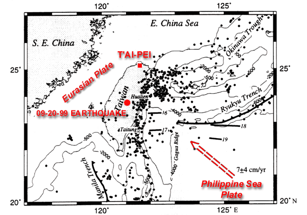
Figure caption. Earthquakes with magnitude greater than or equal to 5.0, occurring between 1964 and 1995. Most large earthquakes are located east of Taiwan and have caused minimal damage. This situation is unlike the September 20 1999 earthquake and aftershocks, which are located in the central part of the island. (Reference: Kao, H., Shen, S. and Ma, K.-F., 1998, Transition from oblique subduction to collision: Earthquakes in the southernmost Ryukyu arc-Taiwan region, J. Geophysical Research 103, 7211-7229.)
The following list shows magnitude 7.0 and greater earthquakes that are located in the zone 22.0-25.0 degrees North by 120.0-122.5 degrees East. This zone closely bounds Taiwan. Only a few of these earthquakes were damaging because most events were east of the island. The columns show year-month-day-origin time-latitude-longitude-focal depth-magnitude. Focal depths for most earthquakes prior to 1952 are unknown.
|
The preceding summary was prepared by seismologists at the U. S. Geological Survey, National Earthquake Information Center, Golden, Colorado.
На основную страницу Список землетрясений
URL: http://zeus.wdcb.ru/wdcb/sep/strong/19990920/stect.htmlLast revision January 26, 2001