Сейсмотектонический обзор для землетрясения
17 августа 1999 г.

По данным    NEIC, USGS

The earthquake likely occurred on a branch of the North Anatolian fault. Although this is the largest earthquake in the epicentral region in this century, the region of the earthquake has a long history of destructive earthquakes. In 1967, a magnitude 7.1 earthquake caused extensive damage along the North Anatolian fault just east of the current shock.

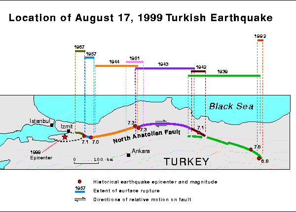
The 900 kilometer-long North Anatolian fault has many characteristics similar to California's San Andreas fault. These two faults are right-lateral, strike-slip faults having similar lengths and similar long-term rates of movement. If a person is looking across a right-lateral, strike-slip fault during such an earthquake, that person would see the opposite side move to the right.

The North Anatolian fault has produced seven large (MS >= 7.0) earthquakes in the period from 1939 through 1999. These earthquakes have ruptured the fault progressively from east to west. The seismic gap on the western part of the North Anatolian fault led Turkish and American seismologists to specify, in published papers, that the zone ruptured by the August 17, 1999, earthquake was a zone of special concern.

Location of the Earthquake

Following are data for the seven large earthquakes that have progressively ruptured the North Anatolian fault:

Date Magnitude Fault Length  
1939 12 26 7.9 - 8.0 MS about 360 km 30,000 deaths. Initiated the westward migration of significant earthquakes on the North Anatolian fault.
(Termed the 1939 Erzincan earthquake.)
1942 12 20 7.1 MS about 50 km (Termed the 1942 Erbaa earthquake)
1943 11 26 7.6 MS about 280 km (Termed the 1943 Tosya earthquake)
1944 02 01 7.3 MS about 165 km (Termed the 1944 Bolu-Gerede earthquake)
1957 05 26 about 7. MS about 30 km (Termed the 1957 Abant earthquake)
1967 07 22 7.1 MS about 80 km (Termed the 1967 Mudurnu Valley earthquake)
1999 08 17 7.8 MS
7.4-7.5 MW
   

Earthquakes on the North Anatolian fault are caused by the northwards motion of the Arabian plate against the Eurasian plate, squeezing the small Turkish microplate westwards. Also, compression in this region is due to the northwards motion of the African plate, which produces subduction at the Cyprus and Hellenic arcs. The small Turkish microplate is bounded on the east by the East Anatolian fault zone (EAFZ), on the north by the North Anatolian fault zone (NAFZ), on the west by a diffuse zone of deformation surrounding the greater Aegean region, and on the south by the Hellenic and Cyprus arcs.

Turkey Plate map
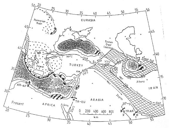
Figure from Rob Westaway, "Present-day kinematics of the Middle East and eastern Mediterranean," Journal of Geophysical Research, Volume 99, pages 12,071 - 12,090, 1994.


На основную страницу       Список землетрясений
URL: http://zeus.wdcb.ru/wdcb/sep/strong/19990817/stect.html
Last revision January 26, 2001