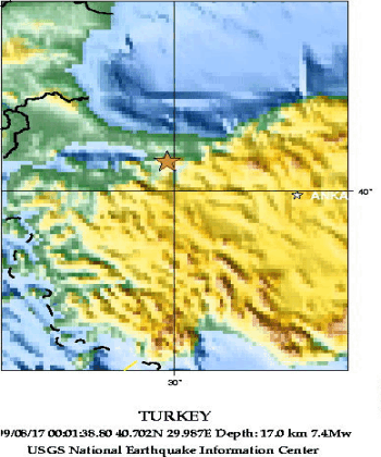
Положение эпицентра землетрясения 17 августа 1999 г.
По данным ГС РАН
Эпицентр землетрясения находился близ промышленного города Измит,
расположенного в 80 км восточнее г. Стамбула.
По данным NEIC, USGS
The Izmit earthquake epicenter was placed about 11 kilometers,
or seven miles, southeast of the city of Izmit. This location
indicates that the earthquake occurred on the northernmost strand of the
North Anatolian fault system. The earthquake originated at a depth of 17
kilometers, or about 10.5 miles, and caused right-lateral strike-slip
movement on the fault. Preliminary field reports confirm this type of
motion on the fault, and initial field observations indicate that
the earthquake produced at least 60 kilometers (37 miles) of surface
rupture and right-lateral offsets as large as 2.7 meters, or almost
nine feet.
Положение эпицентра землетрясения показано на карте, составленной
Национальным Центром информации о землетрясениях Геологической службы США
(NEIC,USGS) и заимствованной с
WEB сайта этой службы.
URL:
http://zeus.wdcb.ru/wdcb/sep/strong/19990817/map.html
Last revision January 26, 2001